Your history. Your inbox.
7 uniquely curated newsletters to choose from.

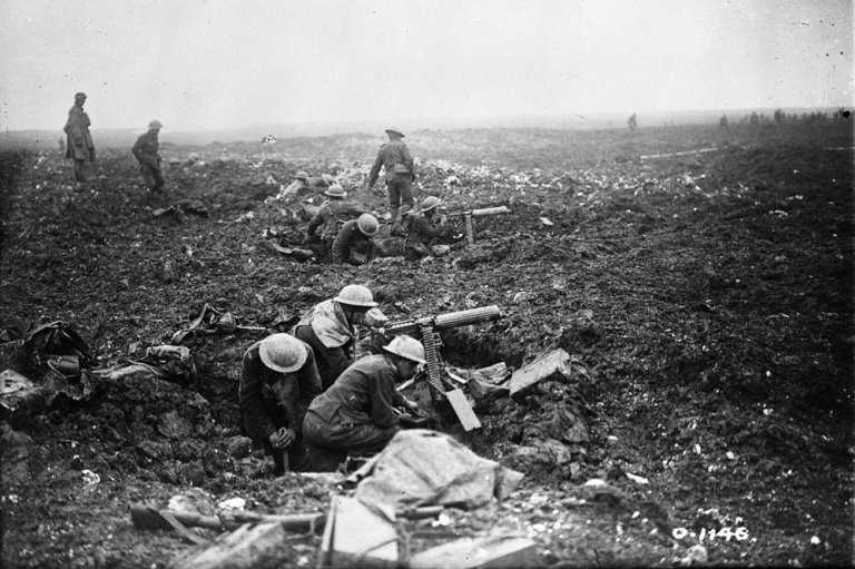
D-Day was an enormous gamble for the Allies. Success would lead to the end of the war while failure would impose a long delay, if not something worse. The cost to the free nations of the world, not to mention those under the yoke of Nazi tyranny, was unthinkable.
One major advantage the Allies held was the ability to photograph occupied Europe almost at will, something the Germans could not do over England. In the months and weeks before D-Day, Canadian, British, and American aircraft conducted thousands of flights to learn everything they could about the enemy defences as well as understand their possible response to an invasion.
Aerial reconnaissance flights continued during operations. The imagery gave commanders a view of the battlefield that was otherwise inaccessible to them. Surviving photos provide us with an invaluable insight into the past.
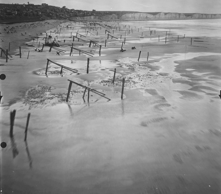
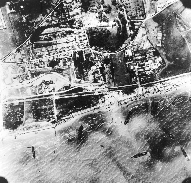
Low level “dicing” shots like this were taken of all possible invasion beaches so the planners could understand the challenges facing the assault troops. This photo of the beach in front of a French town shows the extent of the anti-invasion obstacles installed by the Germans to interfere with any landings.
Posts and ramps, often with mines or artillery shells attached, were designed to rip the bottom out of landing craft. The Allies partially solved this problem by landing at low tide on the morning of June 6, 1944. In the centre of this image behind the truck you can see workers diving for cover as the aircraft zooms overhead.
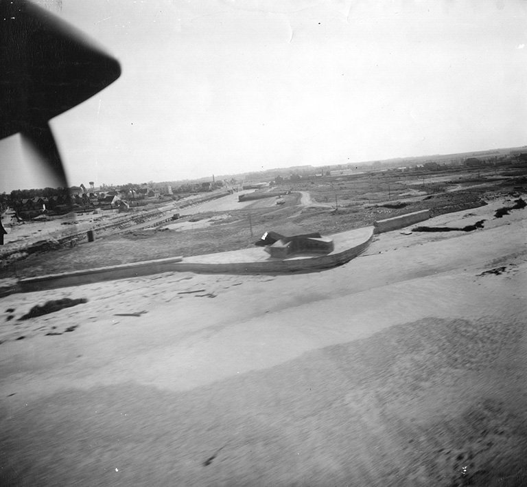
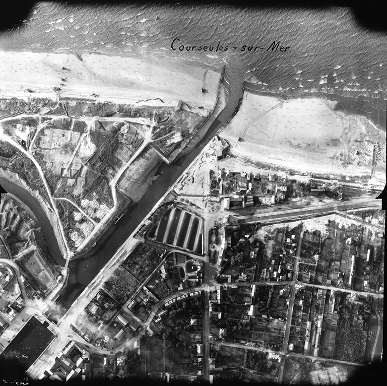
This low-level oblique taken on May 19, 1944, by a P-38 Lightning, a US Army Air Forces reconnaissance aircraft, shows a part of Juno Beach at Courseulles-sur-Mer, where the Canadians landed on D-Day. Visible is the harbour, as well as one of the main German bunkers on the harbour’s west side. The bunker remains there today, while the Juno Beach Centre now sits in the open field behind it.
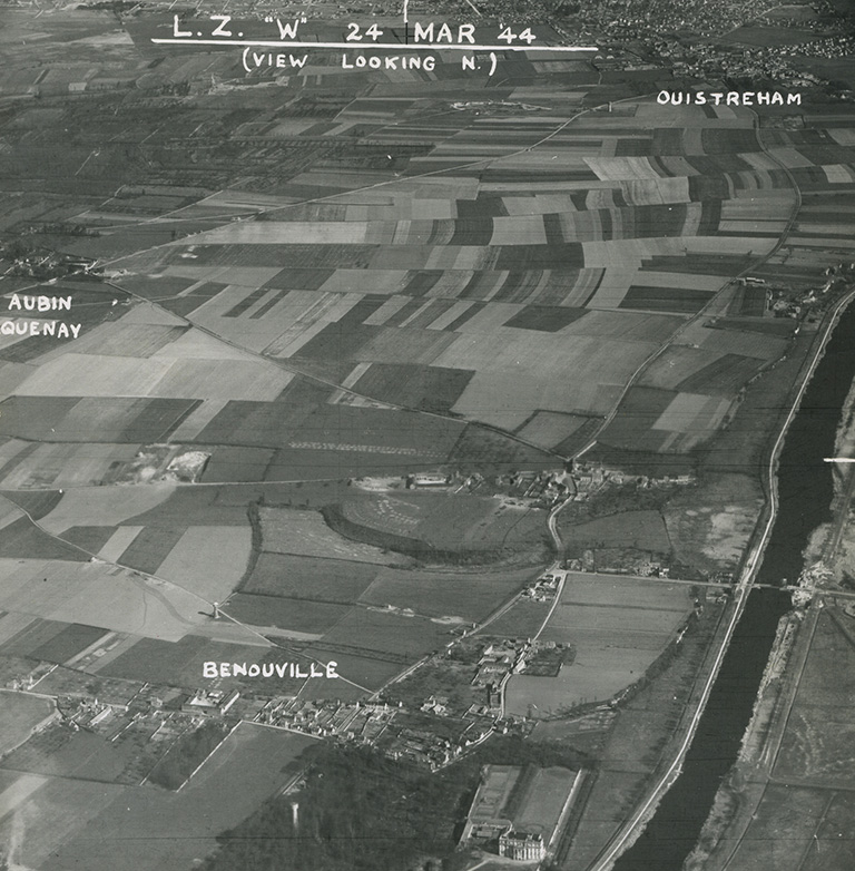
This is an example of the type of excellent intelligence photos available to the assault troops before the battle. This oblique photo was taken on March 24, 1944, and shows the open expanse of Landing Zone W bounded by Ouistreham in the north, St. Aubin-d’Arquenay to the west, Bénouville in the south and the Caen Canal in the west.
The village was the scene of fighting throughout the first day of the battle and was finally captured in an assault by the 2nd Battalion, Royal Warwickshire Regiment at 9 p.m.
At the bottom of the photo is the Château de Bénouville. It has variously been described as a maternity hospital or a shelter for unwed mothers. It was occupied by the Germans at the start of the battle and its high roof offered an excellent vantage point of the battlefield. Pegasus Bridge can be seen crossing the Orne Canal on the right side of the photo.
The bridge crossing the Dives River at Robehomme was the objective of B Company of 1st Canadian Parachute Battalion. This photograph was taken on March 23, 1944, and used to plan the attack on the bridge.
The Canadians were widely scattered in the drop, with many paratroopers drowning in the flooded area east of Drop Zone V. Only thirty men arrived at the rendezvous and they set out for the bridge under the command of Lieutenant Normand Toseland.
Along the way they received unexpected help from a young French girl who offered to guide them to the bridge. Toseland’s group awaited the arrival of British airborne engineers who had the explosives needed to blow the bridge.
When they did not show up, Toseland gathered the small quantity of high explosives carried by his group. The 30-pound charge he assembled was insufficient to do anything more than weaken the structure. Fortunately, a short time later the engineers, led by Lieutenant Jack Inman, arrived and successfully dropped the bridge into the river.
The small party then made their way to the le Mesnil crossroads to join the rest of the Canadian battalion.
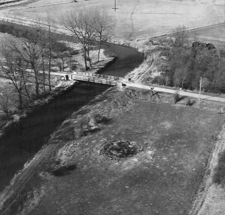
The first stage of Operation Overlord — D-Day — was the landing of airborne troops in France early on the morning of June 6, 1944. The most interesting feature of this photo is Pegasus Bridge, visible in the bottom right corner.
D-Day planners had considered the early capture of the bridge crucial to their plan of holding and defending the high ground on the left flank of the invasion. To accomplish this task, D Company, 2nd Battalion, Oxfordshire and Buckinghamshire Light Infantry, under Major John Howard was tasked to capture the bridge.
They were expected to land their gliders as close to the bridge as possible, and they did. In what Air Marshal Sir Trafford Leigh-Mallory called the finest feat of precision flying in the Second World War, the three gliders of Major Howard’s force landed within metres of their target and quickly captured the bridge.
The impressiveness of this achievement is shown in this air photo, taken a month after D-Day, and shows just how close the gliders landed.
This remarkable air photo shows the beginning of the Canadian assault on Juno Beach. The attack on Mike Red Beach (left of the harbour) and Nan Green Beach (right of the harbour) has just begun as Sherman Duplex Drive Tanks have arrived on the beach after covering some 1,500 metres from their launch point offshore.
Though some accounts say the tanks arrived after the infantry, this photo clearly shows the tanks engaging the German defences before the landing of the infantry. On each side of the harbour a single tank from the First Hussars Regiment can be seen to have driven right up to a German bunker.
On the right of the photo, another Sherman has maneuvered extensively (see the tracks in the sand) as it engages the German defenders in Courseulles. At least one Sherman can still be seen in the water at the top of the photo.
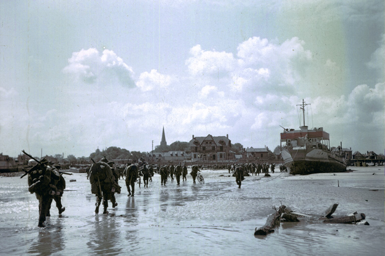
Juno Beach at Bernières-sur-Mer photographed on the afternoon of D-Day. By this time, the town had been captured by the Queen’s Own Rifles of Canada supported by DD Tanks of the Sherbrooke Fusiliers.
As the tide rose, reserve troops, many from 9th Canadian Infantry Brigade, were landed on the beach. Efforts to clear the southern edge of the town took longer than expected and a massive traffic jam (visible on the streets leading towards the top of the photo) developed in the town.
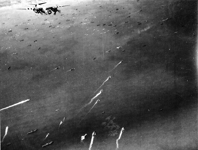
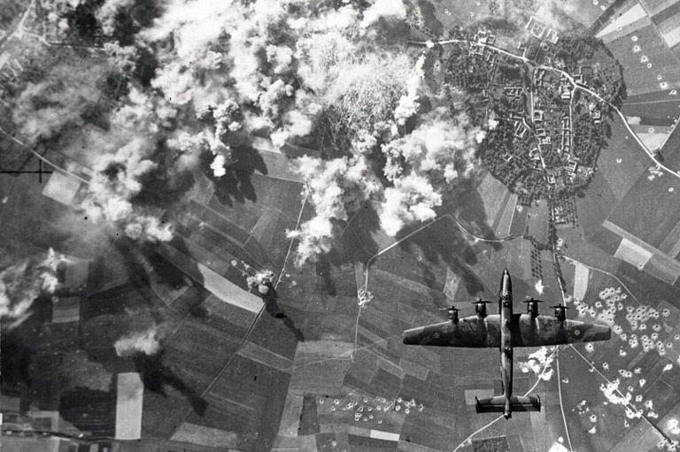
The scale of Operation Overlord is difficult to visualize. The naval force alone totaled 6,939 vessels: 1,213 combat ships, 4,126 landing ships/craft, 736 support ships, and 864 merchant ships. This photo shows a US Army Air Forces B-26 Marauder, with black-and-white invasion stripes on its wings, flying over a small portion of the invasion fleet on June 6, 1944.
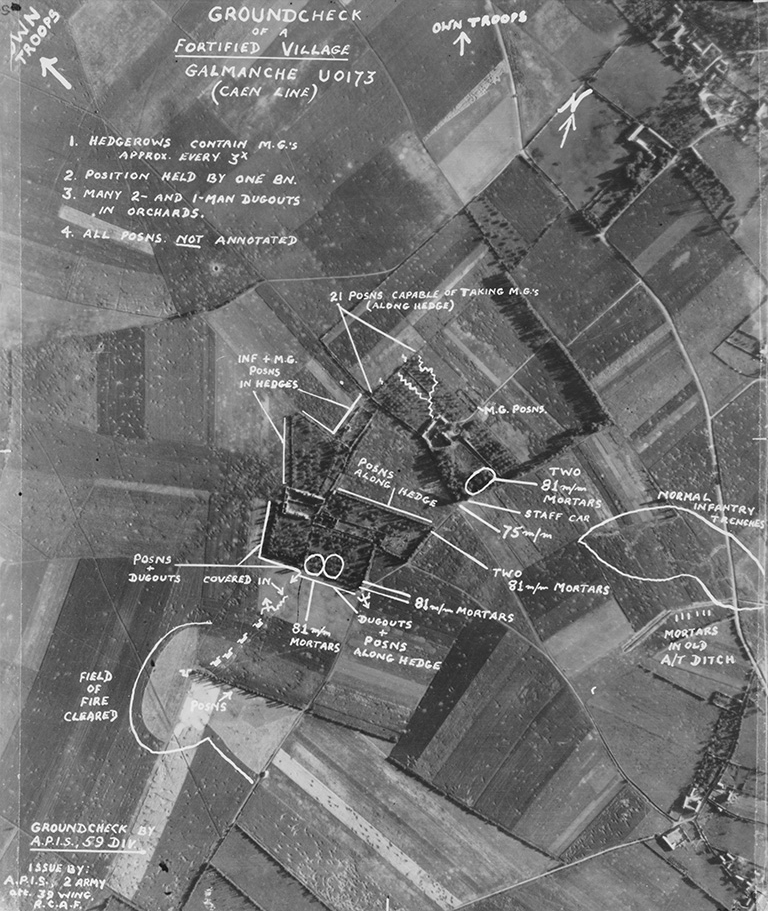
This air photo illustrates a German battalion-strength defensive position near the village of Galmanche, north of Caen. The photo was taken by aircraft of 39 RCAF Reconnaissance Wing and the ground check notations were made by the Air Photo Interpretation Section of 59th British Division in preparation for Operation Charnwood, the attack on Caen, July 8, 1944.
The notations show the wealth of information which an experienced interpreter can glean from an air photo. Among other details noted are dug-in tanks, mortar positions, trenches and the position of friendly troops. The photo interpreter does not rely strictly upon one photo, but will base his assessment on comparisons between older and newer photos to find changes, pilot observations, and intelligence supplied by the ground forces.
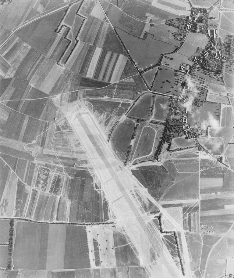
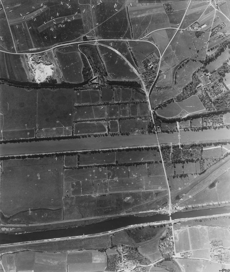
This photograph, taken on July 3, 1944, shows Airfield B5 at le Fresne-Camilly near Thaon, about 10 kilometres south of Juno Beach. Its construction was started less than ninety-six hours after D-Day and it was operational by June 17. There are numerous aircraft visible including single-engine fighters (Spitfires and Typhoons) and twin-engine transports (C-47 Dakotas).
We hope you’ll help us continue to share fascinating stories about Canada’s past by making a donation to Canada’s History Society today.
We highlight our nation’s diverse past by telling stories that illuminate the people, places, and events that unite us as Canadians, and by making those stories accessible to everyone through our free online content.
We are a registered charity that depends on contributions from readers like you to share inspiring and informative stories with students and citizens of all ages — award-winning stories written by Canada’s top historians, authors, journalists, and history enthusiasts.
Any amount helps, or better yet, start a monthly donation today. Your support makes all the difference. Thank you!
Advertisement

Canada’s History Archive, featuring The Beaver, is now available for your browsing and searching pleasure!

Beautiful woven all-silk necktie — burgundy with small silver beaver images throughout. Made exclusively for Canada's History.