Your history. Your inbox.
7 uniquely curated newsletters to choose from.

In Annapolis County, Nova Scotia, students and seniors are using their skills — both new and old — to reveal their community’s history one layer at a time.
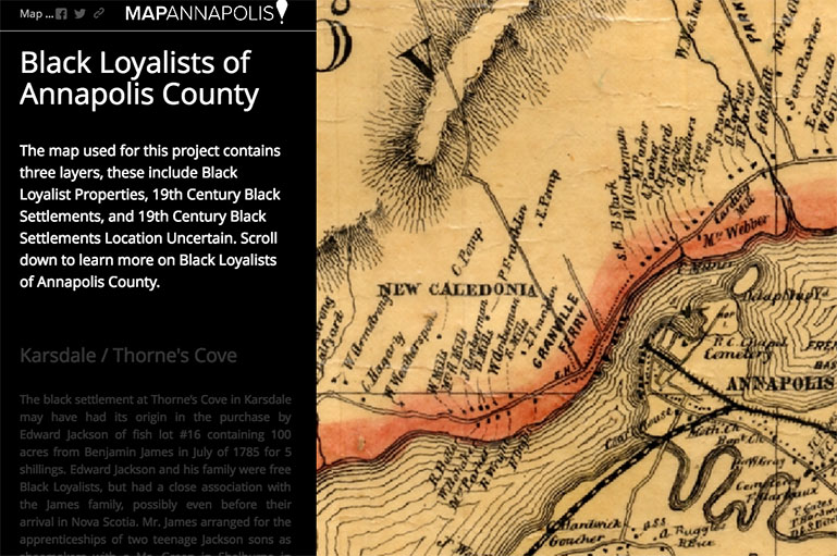
The Annapolis Community Mapping Project, or Mapannapolis, pairs area residents’ historical knowledge with the Web-mapping know-how of local college students to enhance online historical maps of the region.
The intergenerational project continually unveils pieces of history that are then detailed and documented on historical geographic maps. (See Mapannapolis.ca.)
“Mapannapolis is a platform for communities to share their view of Annapolis County with the world,” said Heather LeBlanc, the project’s designer.
What started out as an application for a federal grant in 2012 became a continuing, collaborative project between local volunteers — many of them seniors — and students from the Centre of Geographic Sciences (COGS) at Nova Scotia Community College.
“Project participants are passionate about their stories,” LeBlanc said. “Our community map-makers access the students’ specialized knowledge while sharing their community interests with them. Students consolidate their learning by in turn becoming teachers. It is a symbiotic relationship.”
The project has revealed previously unknown details about the region. For example, while digitizing old maps of the Annapolis River estuary, the team uncovered cartographic evidence of up to forty-five wharves that had disappeared over time.
Other mapping projects focus on Acadian history and on the historic settlement, including properties and structures, of the Black Loyalists who fled to Canada after the American Revolution.
“Every generation leaves a story of its times,” LeBlanc said. “Trails from here to there, commercial wharves built to support a local economy, railway tracks, forts, period architecture, [and] national parks.”
When the project began, it was an elective for COGS students. Now the mapping project is part of their core studies, with weekly mapping meetings during college semesters.
The project draws help from other groups as well. Recently, the mapping group teamed up with Parks Canada to design a geographic information system (GIS) map of Garrison Cemetery at Fort Anne National Historic Site in Annapolis Royal.
According to LeBlanc, about 125 volunteers since 2012 have left their mark on the project, with more joining each year. And every new piece of local history that is discovered adds more and more layers to the map.
“What is happening now in Annapolis County,” LeBlanc said, “is history tomorrow.”
Advertisement

Nominate an exceptional history project in your community for this year’s Governor General's History Award.