Samuel Holland: Charting a Course
In honour of the 250th anniversary of surveyor Samuel Holland’s visit to Canada’s East Coast, the Confederation Centre of Arts in Charlottetown, Prince Edward Island, played host to one of his famous maps.
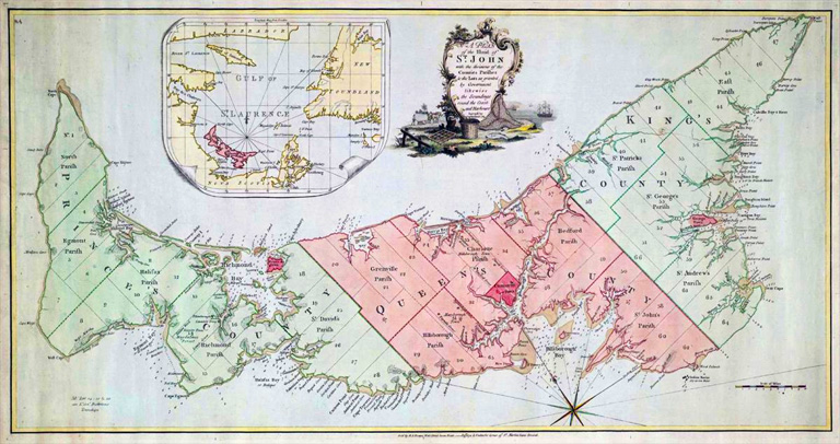
The Imperial Designs: Samuel Holland’s 1765 Map and the Making of Prince Edward Island exhibit opened July 4 and ran until December 31, 2015. It was designed to illustrate Holland’s role in increasing the understanding P.E.I.’s geography.
Holland played an integral part in the surveying of the island and the 3.9-metre map he created will be part of the exhibition this summer.
Holland was born in the Netherlands in 1728. He was raised by two of his aunts due to the presumed death of his parents, Johan Holland and Johanna Buikers.
As an adult he spent a brief period in the Dutch artillery before moving to England in search of something better, leaving his wife, Gertrude Hasse, and their child behind.
After becoming a lieutenant in the Royal Americans in 1756, he was sent to North America in 1757 to participate in the Seven Years War between the British and French. As assistant engineer to the British, Holland became part of the expedition to Louisburg. This led him to being with the British forces for the final battle of Louisburg in July, 1758.
Following this, he was commissioned to make charts and surveys of the St. Lawrence River to assist with the assault on the French stronghold of Quebec in 1759. At the end of the campaign Holland continued surveying and was promoted again.
With the new title of Surveyor General of Quebec, he returned to North America in 1764 and began an extensive survey of all British land north of the Potomac River, which flows through Washington, D.C. It was during this survey that he created his map of Prince Edward Island.
He divided the Island into sixty-seven sections — called townships — that were given out to wealthy British politicians and military personnel. In 1769, the Island, formerly called Île Saint-Jean, became an independent colony with Charlottetown (named after Queen Charlotte) as its capitol.
With aid from map engraver Thomas Jeffreys, Holland completed a detailed map by 1775 that divided the Island into three counties, named Prince, Queens and Kings, as well as fourteen parishes.
Holland went on to survey Cape Breton, the Gulf of St. Lawrence, and the eastern seaboard from Maine to Rhode Island prior to his death in Quebec in 1801.
Themes associated with this article
Advertisement